Updated Planted Trees Map Reaches Near-Global Coverage

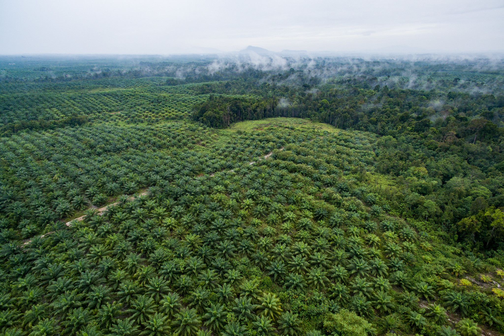
Oil palm plantation in Sentabai Village, West Kalimantan, Indonesia. Credit
-Nanang Sujana/CIFOR
Determining the boundaries of different forest types allows us to better understand how forests are changing over time. A longstanding limitation of the tree cover data available on Global Forest Watch (GFW) has been the inability to differentiate planted forests and tree crops from primary and secondary natural forests. There is no globally consistent data available on the location of planted trees, making it difficult to determine whether tree cover change occurred in natural forest or if it was simply harvesting or management activities in planted trees.
In 2019, GFW and World Resources Institute published the original Spatial Database of Planted Trees (SDPT) to fill this data gap by compiling data sources on planted tree boundaries across the globe. This effort allowed GFW users to view the location of planted trees on the GFW map and focus tree cover loss and gain statistics on change inside or outside planted tree areas.
Now, a new version of the SDPT is available on GFW, which provides broader geographic coverage and several key updates that improve its application to global forest monitoring and management.
What is the Spatial Database of Planted Trees (SDPT)?
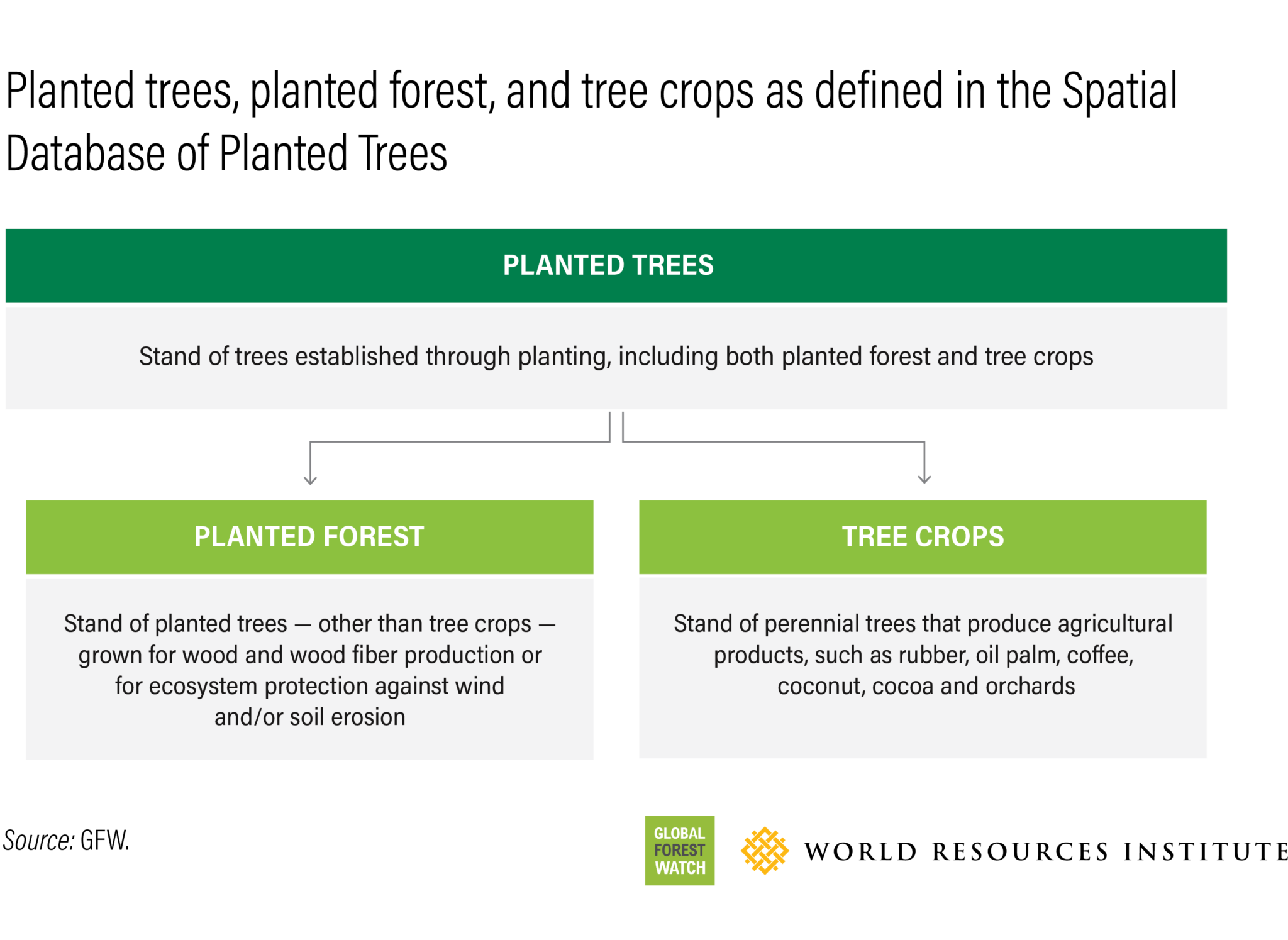
The SDPT aims to spatially differentiate planted forests and tree crops from natural and seminatural forests on a global scale. We conducted extensive research and outreach to governments, civil society organizations and researchers to compile, synthesize and integrate national and regional data sources of the world’s planted trees into the SDPT.

The SDPT includes key information on each integrated data set, including the planted tree type (planted forest vs. tree crop), original data source information and carbon removal factors — or the rate at which planted trees remove atmospheric carbon dioxide and store it in biomass. Where available, the SDPT also includes species information, as well as the method and year(s) of imagery used to determine the planted tree boundary.
The SDPT was established as a living database that will continue to evolve as new data becomes available. The recent publication of an updated version of SDPT (v2.0) reflects this aim and provides significant updates to the initial (v1.0) database.
Users can download the v2.0 database here. The SDPT is also available as the tree plantation layer on the GFW map and is included in several analyses on the GFW dashboard.
What’s new in SDPT version 2.0?
A range of improvements have been made to the SDPT in v2.0 based on new global and national data sources. These include:
1. Near-global coverage
Coverage in v2.0 has expanded from 82 countries in v1.0 to a total of 158 countries represented. Based on the newly compiled data, v2.0 reports approximately 329 million hectares (Mha) of planted trees worldwide in 2020, made up of 264 Mha of planted forests and 65 Mha of tree crops. This represents 8% of total global tree cover (an area roughly the size of India).
2. Tree species information
SDPT v2.0 added or updated tree species information for 39 countries and now includes species-level information for 52 out of the 158 countries covered. Users can view available species information by downloading the database and referencing the sciName data attribute.
3. Planting year information
A new planting year attribute has been added to the database that provides the latest approximate year that an individual area was planted. Researchers at Tsinghua University were able to detect the year of planting in SDPT v2.0 using the LandTrendr algorithm on a time series of Landsat images from 1982 to 2020. Results from this analysis were added to each planted tree area and are available by downloading the database and referencing the plantedYear data attribute.
4. Carbon removal factors
Carbon removal factors, or carbon sequestration rates, have been assigned to planted trees represented in SDPT v2.0 that were not included in v1.0. In addition to carbon removal factors for aboveground biomass, belowground biomass and the standard deviations of removal factors, the database includes notes on methods and sources for each removal factor. Users can access carbon removal factor information by downloading the database and referencing attributes such as removalFactorAGCBGCMgHaYr, removalFactorAGCBGCstdevMgHaYr, removalFactorSource and removalFactorNotes.
How can the SDPT be used?
The SDPT exists first and foremost to differentiate the geographic extent of planted trees from natural forests on a global scale, leading to easier identification of “natural forest” areas. Already, SDPT v2.0 is being used as an input layer into the Science Based Targets Network (SBTN) Natural Lands Map to filter out planted forests and produce a natural forest class.
Specific SDPT attributes, such as species information, also have important global applications. Enforcement actors, such as United States government customs agencies, can use SDPT species information to expedite inspections of timber shipments. The database can help confirm whether there are other planted timber forests of the same species within the stated country of origin, as this impacts the legality of the import. The removal factors can be used to estimate carbon sequestration rates over large areas of planted trees where plot-level carbon measurements are not available.
Beyond these specific applications, the SDPT has implications for global forest monitoring and management. It can aid in tracking where and when planted trees may be replacing natural forests and help monitor the impact of these planted forests across diverse landscapes. This can lead to more effective tracking of national and global progress towards major international commitments associated with forests, climate and biodiversity.
Future plans for the SDPT
While major challenges remain in mapping planted trees, we expect to see continued, significant advances in large-scale planted tree mapping as well as improvements to national- and regional-scale data over time. The SDPT will continue to integrate these sources across all scales to provide users with the most detailed spatial information available. Incorporating more species-specific data into the SDPT is a key part of this effort. This includes species information taken directly from image-interpreted data sets as well as integrating non-spatial species information derived from literature reviews.
Users can explore the tree plantations layer on GFW and can download the data. For more information on the SDPT v2.0 update, read the technical note here.
The SDPT compiles data from a variety of sources. If you have spatial data on planted trees that you think should be incorporated into the data set, please let us know here.
Additional minor updates have been made to the SDPT in a version 2.1 incorporating new data in Brazil, Cambodia, Cote d’Ivoire and Ghana. Access the latest version here.


